An excellent site with an interactive map showing the major rail lines in Kanagawa. There are 13 of them.
http://www.kanagawa-kankou.or.jp/english/access/index.html
Includes a good PDF map to download.
Kimaron
Thursday, December 30, 2010
Kanagawa?
Ok, the easy description from Wiki :
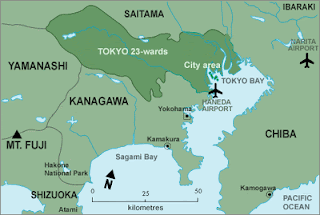
"Kanagawa is a relatively small prefecture located at the southeastern corner of the Kanto Plain. wedged between Tokyo on the north, the foothills of Mt Fuji on the northwest, and Sagami Bay and Tokyo Bay on the south and east. The eastern side of the prefecture is relatively flat and heavily urbanized, including the large port cities of Yokohama and Kawasaki."
Population : 9,029,996
Population density : 3,738 people per square kilometer
Kanagawa Official Website in Foreign Languages http://www.pref.kanagawa.jp/menu/page/04.html
Kimaron
A Beginning...
Well hello, this is a basic blog on places I have visited in Kanagawa. I shall be making an entry at least once a week on my travels.
I hope you enjoy or get some useful information from this blog.
Kimaron
I hope you enjoy or get some useful information from this blog.
Kimaron
Subscribe to:
Comments (Atom)
